Development of the integrated hydrological-hydraulic model
Work Package Leader – Prof. Gabriella Petaccia, Department of Civil Engineering and Architecture, University of Pavia
This will be dedicated to the development of the methods, which constitute the integrated hydrological-hydraulic model. The methods will be calibrated using data collected in WP1 and WP2.
1) A spatially distributed soil water balance model will be developed to assess soil moisture at different depths. The distributed hydrological model will simulate the water fluxes (infiltration, percolation, horizontal movement of water, evaporation, transpiration) between several soil layers (4 to 6), along with the temporal evolution of the groundwater level and of the surface and subsurface runoff. In order to perform the most reliable simulation as possible, topographic information, soil texture and land use data will be considered along with rainfall and temperature estimates (obtained from in situ and satellite data) over the study area. Finally, the model code will be made freely available to the scientific community.
2) A hydrological-hydraulic model (overland flow) will solve the 2D shallow water equations written in conservative form using up to date numerical solvers and proper source term discretization, in order to simulate the flood propagation caused by rainfall. The infiltration rate will be evaluated by means of soil moisture maps and rainfall data (WP2) and will be added in the 2d hydraulic model as source terms to get the overland flow model.
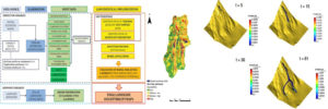
3) A data-driven methodology, based on the Genetic Algorithm Method (GAM), will be applied for identification of landslide prone areas. The adopted procedure will guarantee: i) selection of the geomorphological, geological and land use predisposing factors to shallow landslides, by means of a robust statistical method (Akaike Information Criterion-AIC repeated within 100-fold bootstrap procedure of random selection of training and test data sets); ii) the built-up of a susceptibility model, which is obtained as the mean of a repeated holdout method of 100 iterations calculated, in all training and test sets; iii) the evaluation of model uncertainty, by means of the Receiving Operator Characteristic (ROC) curve. Estimated shallow landslides triggering zones will be integrated with a lagrangian model for evaluating landslides run out. This allows simulating large displacement between particles that may change significantly their relative position without loss of numerical accuracy due to mesh deformation, thus overcoming the intrinsic limitations of traditional grid-based methods. Furthermore, the SPH method is suitable for simulating rapidly mowing surfaces and interfaces involving violent impacts, thus applying successfully to the dynamics of granular flows and landslides with relative ease compared to traditional grid-based techniques.